
Tracking 98-L: What to know right now
It’s been a pretty quiet hurricane season so far, but recently Hurricane Fiona has caught the attention of all of us along the Gulf and East Coasts to remind us that this is not over yet.
By now, you’re hearing the name 98-L quite a bit, and you’ve likely seen plenty of scary images showing a massive hurricane in the Gulf of Mexico next week. That’s unnerving for sure. At Storm Guides, we believe that knowledge conquers fear. So with that, let’s talk about 98-L and it’s possible future.
CURRENT:
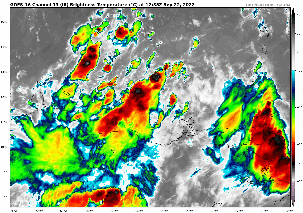
This big messy blob above is 98-L. Not much to look at, right? It’s not even close to becoming a tropical system at this time. So, for now, take a nice deep breath. 98-L is currently located in the southern edge of the Caribbean Sea between South America and Puerto Rico, and moving westward. So let’s talk about potential strengthening and track now.
WHAT’S NEXT:
First and foremost, Fiona has to get away from 98-L for the system to have any hope of a future. That is happening as we speak. Hurricane Fiona is moving northward through the Atlantic Ocean and will eventually make a landfall in Nova Scotia later this week and weekend.
I will admit that models are really aggressive on development of 98-L. Let’s look at two long-rage models: the GFS and the EURO.
GFS:
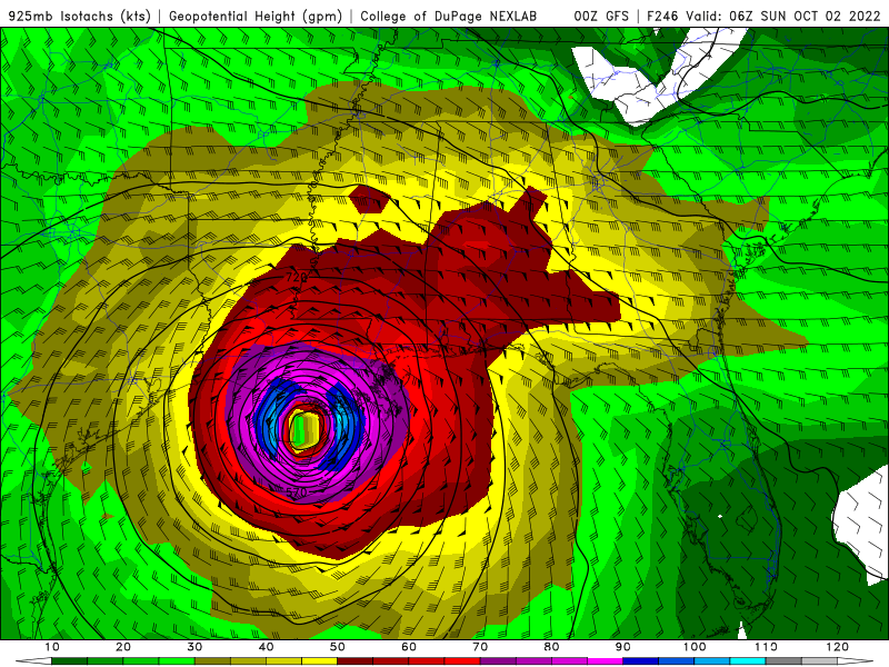
I do not want this image to make you panic. The GFS is currently the only model to show this outcome. It’s the outlier of the models right now, but in transparency I think it’s important to show what models are saying.
The 00z GFS shows a potential landfall overnight on Sunday, October 2nd between Lafayette, LA and Baton Rouge, LA as a category 2 or 3 hurricane.
EURO:

The EURO is onboard with the overall thinking of most other models, and therefore holds more confidence at this time. A faster moving storm and a much further east landfall.
The 00z EURO shows a possible landfall in the morning of September 29th also as a category 2-3 hurricane between Tampa, FL and Gainesville, FL.
WHY SO DIFFERENT:
Firstly, it’s because 98-L is nothing right now. Models don’t have a center of circulation to hold onto and therefore there’s a lot of outcomes while they guess where it is now. Secondly, the steering currents are much different on the two models shown above.
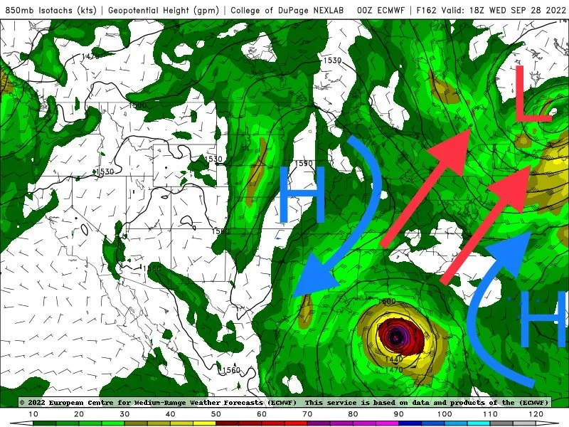
The EURO has future Hermine sandwiched between two High pressure systems and being pulled northward by a trough over the NE. This would steer the system into Florida.
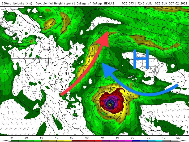
The GFS is much more progressive with the movement of the two highs and essentially blocks Florida and the eastern US. This would force the system westward and into Louisiana or possibly even further west.
Lots to watch and we will update as necessary. If you have any questions at all, please message us on on Facebook page and we will gladly help you out.